How to Use GPS Technology for Precision Agriculture and Improved Efficiency
GPS technology in precision agriculture enhances farming efficiency by enabling accurate mapping, precise application of resources, and optimized machinery operation, leading to improved crop yields and reduced costs.
Discover how to leverage GPS technology for precision agriculture and improved efficiency, revolutionizing your farming practices and boosting profits.
Understanding GPS Technology in Agriculture
GPS technology has become an indispensable tool in modern agriculture. It allows farmers to monitor and manage their fields with unparalleled accuracy, making operations more efficient and sustainable.
This powerful technology not only optimizes resource use but also helps in making informed decisions based on real-time data, leading to increased yields and reduced environmental impact.
What is GPS and How Does it Work?
GPS, or Global Positioning System, is a satellite-based navigation system providing location and time information anywhere on or near the Earth where there is an unobstructed line of sight to four or more GPS satellites.
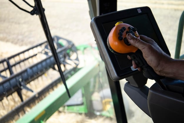
In agriculture, GPS receivers on tractors, combines, and drones calculate their precise location, which is then used for various applications like automated steering, variable rate application, and yield monitoring.
Key Benefits of GPS in Farming
- Increased Accuracy: GPS provides precise location data, reducing overlaps and skips in field operations.
- Improved Efficiency: Automated steering and precise application save time and resources.
- Cost Savings: Reduced input costs, such as fertilizers and pesticides, lead to significant savings.
- Data-Driven Decisions: GPS-enabled data collection helps farmers make informed decisions based on real-time field conditions.
GPS technology transforms traditional farming practices into a high-tech, data-driven operation.
Implementing GPS for Precise Field Mapping
One of the primary applications of GPS technology in agriculture is precise field mapping. Accurate maps are the foundation for effective precision agriculture, guiding various field operations.
By creating detailed maps, farmers can identify variations in soil types, nutrient levels, and crop health, allowing them to tailor their management practices accordingly.
Creating Accurate Field Maps
To create precise field maps, farmers use GPS receivers to record location data while driving or flying over their fields. This data is then processed to generate detailed maps showing various features.
These maps can be used to identify areas needing specific attention, such as low-yielding zones or areas with nutrient deficiencies.
Applications of Precise Field Mapping
- Variable Rate Application: Applying fertilizers, pesticides, and seeds based on specific needs in different areas.
- Zoning the Field: Dividing the field into management zones based on soil types, topography, and yield data.
- Water Management: Optimizing irrigation systems by identifying areas that require more or less water.
- Soil Sampling: Guiding soil sampling efforts to collect representative samples from different zones.
Accurate field mapping ensures that resources are applied where they are needed most, maximizing efficiency and minimizing waste.
Enhancing Crop Yields with GPS-Guided Planting
GPS technology also plays a crucial role in enhancing crop yields through precise planting. By using GPS-guided planting equipment, farmers can ensure uniform seed spacing and depth, optimizing plant development.
This precise planting leads to better plant stands, improved nutrient uptake, and increased yields.
Benefits of GPS-Guided Planting
- Uniform Seed Spacing: Ensures each plant has adequate space to grow, reducing competition.
- Accurate Seed Depth: Optimizes germination rates and seedling establishment.
- Reduced Overlaps: Minimizes double planting, saving seeds and reducing plant density issues.
- Improved Plant Stands: Promotes healthy and uniform plant development.
GPS-guided planting provides a foundation for strong and consistent crop growth.
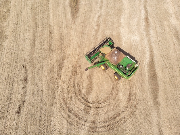
Monitoring and Optimizing Harvesting with GPS
Harvesting is a critical phase of crop production, and GPS technology can significantly improve its efficiency. GPS-equipped combines and harvesters collect yield data in real-time, providing valuable insights into crop performance.
This data is then used to create yield maps, which reveal variations in productivity across the field and inform future management decisions.
Using GPS to Collect Yield Data
GPS-equipped combines measure the amount of crop harvested at specific locations within the field. This data is linked to the GPS coordinates and stored for later analysis.
Yield maps can be used to identify high- and low-yielding areas, helping farmers understand the factors influencing crop productivity.
Optimizing Future Harvests
- Identifying Problem Areas: Pinpointing areas with consistently low yields, indicating potential issues with soil or pests.
- Variable Rate Harvesting: Adjusting harvesting parameters based on yield data, such as combine speed and header height.
- Data-Driven Decisions: Using yield maps to inform decisions about fertilizer application, planting density, and crop selection.
GPS-driven harvesting optimization improves overall productivity and profitability.
Variable Rate Application: Optimizing Resource Use
Variable rate application (VRA) is a key component of precision agriculture, enabled by GPS technology. VRA involves applying inputs such as fertilizers, pesticides, and seeds at varying rates across the field based on specific needs.
This approach maximizes resource efficiency, reduces environmental impact, and improves crop yields.
How VRA Works
VRA systems use GPS-collected data, such as soil maps, yield maps, and sensor data, to determine the appropriate application rate for different areas of the field. The data is fed into a controller that adjusts the application equipment in real-time.
For example, areas with nutrient deficiencies receive higher fertilizer rates, while areas with adequate nutrients receive lower rates, preventing over-application and reducing costs.
Benefits of Variable Rate Application
- Optimized Resource Use: Applying inputs only where they are needed most, reducing waste and costs.
- Improved Crop Health: Providing plants with the precise nutrients they need, promoting healthy growth.
- Reduced Environmental Impact: Minimizing the risk of nutrient runoff and pesticide exposure.
- Increased Yields: Achieving higher yields by optimizing resource allocation across the field.
VRA systems guided by GPS offer a sustainable and efficient approach to crop management.
Integrating GPS with Other Farm Technologies
GPS technology is most effective when integrated with other farm technologies. Combining GPS with sensors, drones, and data analytics platforms creates a comprehensive precision agriculture system.
This integration allows farmers to gather and analyze vast amounts of data, making informed decisions and optimizing their operations.
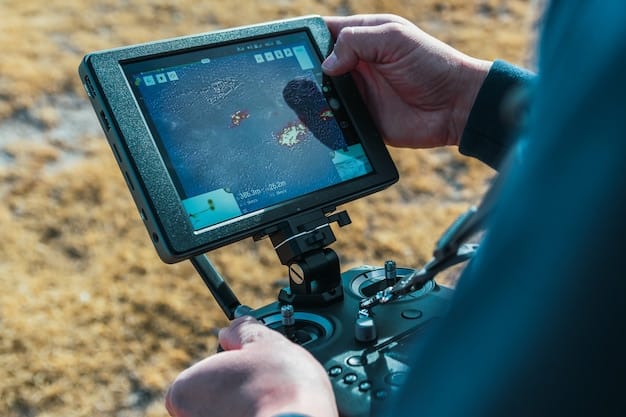
Role of Sensors and Drones
Sensors placed throughout the field can collect data on soil moisture, nutrient levels, and plant health. Drones equipped with GPS and cameras can capture aerial images, providing a bird’s-eye view of the field.
This data is combined with GPS data to create detailed maps and inform management decisions.
Data Analytics and Decision Support Systems
Data analytics platforms process the data collected from GPS, sensors, and drones, providing insights into crop performance and identifying opportunities for improvement.
Decision support systems use this data to generate recommendations for irrigation, fertilization, and pest control, helping farmers optimize their operations.
By integrating GPS with other technologies, farmers can create a powerful precision agriculture system that improves efficiency, sustainability, and profitability.
| Key Point | Brief Description |
|---|---|
| 📍 GPS Field Mapping | Accurate mapping for tailored management practices. |
| 🌱 GPS-Guided Planting | Ensures uniform seed spacing and depth for better growth. |
| 🚜 GPS Harvesting | Collects yield data in real-time to optimize future harvests. |
| 💧 Variable Rate Application | Applies inputs at varying rates based on specific needs. |
Frequently Asked Questions
▼
Precision agriculture is a farming management concept based on observing, measuring, and responding to inter and intra-field variability in crops. It aims to optimize returns on inputs while preserving resources.
▼
GPS improves farming efficiency by enabling precise field mapping, GPS-guided planting, optimized harvesting processes, and variable rate application, leading to reduced waste and increased yields.
▼
Variable rate application optimizes resource use, improves crop health by providing plants with precise nutrients, reduces environmental impact by minimizing runoff, and increases yields across the field.
▼
Yes, drones equipped with GPS and cameras can capture aerial images, providing a bird’s-eye view of the field. This data is combined with GPS data to create detailed maps and inform management decisions.
▼
Yield maps identify high- and low-yielding areas, helping farmers understand factors influencing crop productivity. This data informs decisions about fertilizer application, planting density, and crop selection, improving future harvests.
Conclusion
By leveraging GPS technology, farmers can transform their operations into efficient, sustainable, and profitable enterprises. GPS-guided systems play a crucial role in achieving higher yields, reduced input costs, and improved resource management, ensuring long-term success in the agricultural industry.


